In the Philippines the southwest monsoon of May to October is known as “Habagat” and is characterized by hot and humid weather, frequent heavy rainfall, and a prevailing wind from the west. In winter the dry winds of the northeast monsoon, November through April, are known as the “Amihan” and bring strong easterly weather and little rain. The term ‘monsoon’ itself is traditionally defined as a seasonal reversing wind accompanied by corresponding changes in rain, but is now used to describe seasonal changes in wind and rain associated with changes in season from summer to winter. The term ‘monsoon’ was first used in English in British India and neighbouring countries to refer to the big seasonal winds blowing from the Bay of Bengal and Arabian Sea in the southwest bringing heavy rainfall to the area. As a general rule, the Philippines’ Amihan weather pattern begins sometime in September or October and ends sometime in May or June; this does however vary year to year.
According to the meteorologists, monsoons can be called large-scale sea breezes brought about by differential heating of land masses compared to oceanic water bodies. Water is much more effective at ‘absorbing’ heat than the land meaning that the surface of land-masses heat up quicker than oceans. Hot air over the land tends to rise, creating an area of low pressure and this creates a steady wind blowing toward the land; bringing the moist near-surface air over the oceans with it (the air over the oceans being full of water vapour). This means that during summer when the land is being heated in a big way, moist air flows off the oceans and when hitting elevated land masses, rises and cools (orographic lifting), forming clouds and rain (just ask the Indians about the Himalayas and rain during their summer monsoon). In winter when the land stops getting heated quite so effectively, the oceans are still hot from summer meaning that wind direction reverses flowing off the land masses; hence seasonal changes in wind direction. In effect for this part of the world, the land mass of Eurasia gets hot enough in summer for convection to overcome the more routine ‘trade wind’ direction of air flow. Monsoons are therefore similar to sea and land breezes, a term usually referring to the localized, daily cycle of wind changes near coastlines, but they are much larger in scale, stronger and seasonal.
Of course things are a bit more complex than this with ‘coriolis’ deflection turning moving air masses in a ‘circular’ manner and in discrete masses known as ‘Hadlee’ convection cells; coriolis deflection resulting from us living on the surface of a rotating globe and being the process leading to water turning as it goes down the plug-hole. In the northern hemisphere the deflection is to the right resulting in ‘sub-tropical high pressure’ systems moving west to east in middle latitudes with air rotating cyclonically or in a clockwise direction. These high pressure systems pass above the Philippines and sailors in this part of the world see the descending arm of these as stiff ENE or NE winds lasting for several days followed by, if one is lucky, a few days of light conditions. Also and sadly for those trying to move north-east and especially east, these easterlies produce an awful, close and very steep sea that makes sailing to windward an exercise of near futility during the Amihan. Unfortunately moving north and north-east with the summer Habagat and south-westerlies means running the risk of encountering one of the ubiquitous ‘typhoons’ (for those hailing from more antipodean waters read that as cyclone) that race across the Philippines every summer.
From Puerto Princessa to the top of Palawan is around 150 miles and pretty well all NE. From the top of Palawan on the western side there is a 20 mile SW hop down to El Nido but of course this needs to be made up when headed once again north. From Puerto all the way to Borocay some 350 miles away to the east trying to work against the prevailing was to be the way of things and the further north you go, the stronger the winds seem to get; but such is life in the tropics and there are of course other dilemmas.
Dumaran Island is 90 miles from Puerto with an overnight stop in the pass between Dumaran and the much larger Palawan to the west. We were running all the way up the Palawan east coast inside the reefs with indicated channels that are not unreasonably, completely blocked by pearl farms. From the water these farms present as miles of bouys and ropes connected in an impenetrable maze that seems to defy passage and inside Dumaran everything appeared to be completely blocked. Of course there usually is a way through but these ‘clear’ channels are not as indicated on the charts and they are marked with bouys one really needs a telescope to find. The approach seems to be local knowledge and somewhere in the hectares of little black bouys there is usually a couple of security guards on a small ‘Banka’ (narrow pointy boat with a bamboo outrigger on each side) that will point in the appropriate direction. The other option is keep going until you find the gap between the bouys and land and watch your depth sounder carefully. We had already come across some of these navigation ‘aids’ back south near Bugsuk but the further north we travelled the more breathtaking they became.
After three nights and one good sail near the top of Palawan the weather of course went very light for our southward sojourn twenty miles to El Nido and anchor at Coron Coron. We were back into Karst country here, reminiscent of Phang Nga bay in Thailand but without the tourists. Great place El Nido, with the usual stunning Karst islands fully equipped with ‘Hongs’ in the middle. Here though the hongs have more western names such as, ‘Big Lagoon’, ‘Small Lagoon’, (not so) ‘Secret Beach’ and ‘Cathedral Cave’. The locals here run fairly laid back, daily, island hopping ‘tours’ to see the sights but without the teeming masses we were familiar with out in the Andaman Sea; you pretty much get the places to oneself. In chatting to the locals we found a place in the little squatters village nearby where they would do our laundry. Funny that they managed to use all of our laundry detergent on ten pieces of clothing but when we left all of the villagers clothes seemed to have a lovely lemon scent!
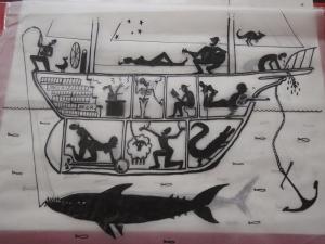
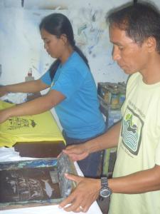
We had a couple of trips out to the islands taking in the sights and a few more days chilling out around El Nido and seeing the more local attractions. Ollie here introduced us to the joy of following Arsenal in the English Premier League with very late nights watching soccer matches. Being the artistic type Jamie produced our long thought over t-shirt design and we had the locals at the ‘Art café’ print boat t-shirts; Sally insisted on a girly design and questioned some aspects of the artwork. Finally and after ten days at El Nido we slipped away on the 31st to start once again our sojourn against the Amihan headed towards Coron and some shipwreck diving.
Coron is only about 85 miles away from El Nido but with the north-easterlies the 85 miles can be a pain so it was pray for light weather and move as quick as the prevailing winds allow. First night was 40 odd miles into a bay at the NE tip of Linpacan Island arriving at dusk after working around the edge of yet more pearl farms. Next day was a lunch stop at an island with the most unlikely name of Binalabag Island and then a short hop into an anchorage at the top of Dicabaito anchorage at the base of Culion Island. The islands all through this area are quite stunning and without the rampant development we had previously seen through Thailand and some of Malaysia; makes one wonder if this was what Thailand was like before tourist development got out of hand? Next morning was a 20 mile northerly run up the west coast of Culion and into the Coron Channel for another 20 miles into Coron, the largest town in the Calamian group. There are about a dozen wrecks in the Calamians courtesy of the Americans giving the Japanese an exercise in aerial diplomacy during world war 2. These are easy to find (marked) and had Trevor somewhat interested requiring we have a look at two of the smaller wrecks on the way in. Next day we went to anchor on Feb03 in the middle of the dive tour ‘bankas’, outside the reef off the Seadive resort and in for a meal with the shipwreck diving multitudes.
Interesting observation since leaving Puerto is the number of Asian tourists in the Philippines. Interesting too is their apparent take on travelling. Sylvia and Ms Chan were two Chinese taking four days in El Nido while on holidays away from China during the Chinese New Year. So what are you up to while in El Nido? Tour B! What’s that? Tour B, tour C today, tour B tomorrow. Oh yea, where does it go? From the beach, 9 o’clock, tour B. Okay sounds good!
Tags: adventure, cruising, diving, Gadfly, ketch, Philippines, Sailing, yacht


February 21, 2012 at 1:55 am |
Love the t-shirt design! Again fantastic information on a well researched topic relevant to the travelling.